Cartesian coordinates
A Cartesian
coordinate system consists of an origin, a pair of axes that intersect at a
perpendicular angle at the origin, and a fixed unit of distance. The axes are
labeled X and Y. Values are positive to the right of the origin on the X axis,
and above the origin on the Y axis. The location of any point can be specified
by an X,Y coordinate pair.
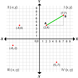
Point locations in the
four quadrants of a Cartesian coordinate system.
Cartesian
coordinates divide a plane into four quadrants as shown in the graphic.
Commonly, the origin of the coordinate system is made to coincide with the
intersection of the central meridian and central parallel of the map. This is a
natural place for it, but it also conflicts with the natural desire of
mapmakers to keep all their map coordinates positive (in effect, to keep the
map within the first quadrant).
False
easting and false northing
This conflict can be resolved with false easting and
false northing, which you learned about in the previous module. Adding a number
to the Y axis origin (false easting) and another number to the X axis origin
(false northing) is equivalent to moving the origin of the system to the
southwest. The easting and northing values are arbitrary—they just have to be
large enough to ensure that every point on the map has positive coordinates.
![]() Question: In this graphic, if a false easting of 10 and
a false northing of 10 were added to the coordinate system, what would the
coordinates of the point (-8,-2) become?
Question: In this graphic, if a false easting of 10 and
a false northing of 10 were added to the coordinate system, what would the
coordinates of the point (-8,-2) become?
(2,8)
(8,2)
(10,10)
(18,12)
Calculating
distance and direction
The main value of Cartesian coordinates is for making
measurements on maps, as the French realized in World War I. The increasing
range of artillery made it possible to train guns on targets that were out of
sight—but on the battlefield, the distance and direction of fire had to be
calculated quickly. Formulas for converting latitude and longitude were too
cumbersome, but Cartesian coordinates offered a satisfactory solution.
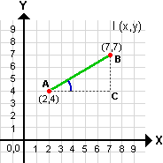
![]() Distance and direction
formulas
Distance and direction
formulas
Look at the two points labeled A and B. Since the distance
between them (green line) can be regarded as the hypotenuse of a right
triangle, you can use the Pythagorean formula to solve it.
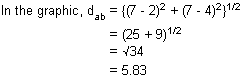
To solve for distance, where dab is the distance
between points A and B:
dab = {(x1 - x2)2
+ (y1 - y2)2}1/2
To solve for direction, where aab
is the direction between points A and B:
tan aab
= {(y1 - y2) / (x1 - x2)}
![]()
The corresponding angle (angle
Since you want the complementary angle (the angle between
grid north and line AB), you subtract from 90.
![]()
So if you are at point A and your target is at point B, you
need to fire your gun a distance of 5.83 units at an angle of 59 degrees.