Albers Equal Area Conic
As you
might suppose, the Albers Equal Area Conic projection is a conic projection
that maintains accurate area measurements. It differs from the Lambert
Conformal Conic projection in preserving area rather than shape and in
representing both poles as arcs rather than one pole as a single point.
(Therefore, the meridians in an Albers Equal Area Conic do not converge at the
poles.) The Albers Equal Area Conic uses two standard parallels, or secant
lines.
First
developed by Heinrich Christian Albers in the early nineteenth century for
European maps, its biggest success has been for maps of
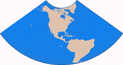
Both poles are represented as arcs rather than as single points. Latitude lines are unequally spaced concentric circles, whose spacing decreases toward the poles..
Scale is
true along the secants or standard parallels and constant along all parallels.
In order to preserve area, the scale factor of a meridian at any given point is
the reciprocal of that along the parallel.