Projected
coordinate systems
The
surface of the earth is curved but maps are flat. To convert feature locations
from the spherical earth to a flat map, the latitude and longitude coordinates
from a geographic coordinate system must be converted, or projected, to planar
coordinates.
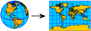
A map projection uses mathematical
formulas to convert geographic coordinates on the spherical globe to planar
coordinates on a flat map.
A
projected coordinate system is a reference system for identifying locations and
measuring features on a flat (map) surface. It consists of lines that intersect
at right angles, forming a grid. Projected coordinate systems, which are based
on Cartesian coordinates, have an origin, an x and a y axis, and a unit for
measuring distance.
Projected coordinate systems are
based on Cartesian coordinates which use a grid. Feature locations are measured
using x and y coordinate values from the point of origin.
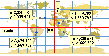
The origin
of the projected coordinate system (0,0) commonly
coincides with the center of the map. This means that x and y coordinate values
will be positive only in one quadrant of the map (the upper right). On
published maps, however, it is desirable to have all the coordinate values be positive numbers.
To offset
this problem, mapmakers add two numbers to each x and y value. The numbers are
big enough to ensure that all coordinate values, at least in the area of
interest, are positive values. The number added to the x coordinate is called a
false easting. The number added to the y coordinate is called a false northing.
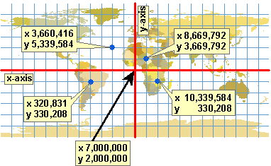
By adding a large number to each x
and y value, all coordinate values on the map are positive. In the graphic
above, a false easting value of 7,000,000 was added to each x coordinate. A
false northing value of 2,000,000 was added to each y coordinate.