Mapping density using attribute values
One way to
map density is to divide the attribute values by the area of each polygon
feature. The process of dividing one attribute by another is called data
normalization.
In ArcMap,
you choose the two attribute fields to use (a value field and an area field)
and ArcMap takes care of calculating the density values. These new values are
used for symbolizing the map but they are not stored in the attribute table;
therefore, your data is not affected. You still must choose a classification
method for grouping the density values and symbolizing them with graduated
colors or graduated symbols.
When normalizing data by area, you should make sure that the attribute field you are normalizing contains counts or amounts (such as population, bushels, or number of species). Be aware that some attribute fields store values that are already normalized, such as population density or bushels per hectare, and these should not be normalized again.
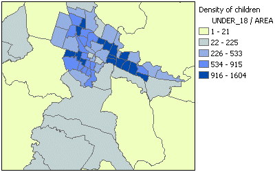
In this example, the Under_18 attribute, which contains the number of people under age 18, is normalized by area in order to show the density of children. The default classification method was used (natural breaks with five classes).