Drawing features to show categories
Category attributes are names, types, or ranks. Each unique attribute value represents a different category. The values can be text or numbers.
|
Category Type |
Layer Name |
Attribute |
Attribute Values |
|
Name |
|||
|
|
Water bodies |
Name |
|
|
|
Data collection stations |
ID |
|
|
Type |
|||
|
|
Stores |
Type |
|
|
|
Zones |
Code |
|
|
Rank |
|||
|
|
Cities |
Size |
|
|
|
Bus stops |
Stop_order |
|
When a layer is symbolized based on a category attribute, features in different categories are represented with a different symbol. Exactly how the symbols differ from one another depends on what you are mapping. For instance, if you were symbolizing roads according to the number of lanes, you might use line symbols with different widths to represent the different lane categories. But if you were mapping roads according to surface type, you might show paved roads with a solid line and gravel roads with a dashed line.
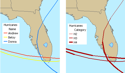
These maps show two different ways of symbolizing a hurricane path layer by categories. On the left, different colors are used to symbolize the paths by name. On the right, different line widths are used to symbolize the paths by hurricane strength.