Linking
features to information
On a GIS map, there's more to a feature
than its location and shape. There's all the information associated with that
feature. For a road, this might include its name, speed limit, and whether it's
one-way or two-way. For a city, this might include its population, demographic
characteristics, number of schools, and average monthly temperatures.
A
particular type, or category, of information associated with a feature in a GIS is called an attribute. For
example, population can be an attribute of a city, country, continent, and
other features. Feature attributes are stored in an attribute table. In an
attribute table, each feature is a record (row) and each attribute is a column,
or field. The attributes for all the features in a layer are stored in the same
attribute table.
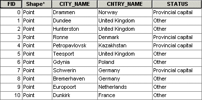
This attribute table for a layer of
cities stores each feature's ID number, shape, name, the country in which it's
located, and its status.
A feature
on a GIS map is linked to its record in the
attribute table by a unique numerical identifier (ID). Every feature in a layer
has an identifier. It is important to understand this one-to-one relationship
between feature, identifier, and attribute record. Because features on the map
are linked to their records in the table, you can click a feature on the map
and see the attributes stored for it in the table. When you select a record in
the table, the linked feature on the map is automatically selected as well.
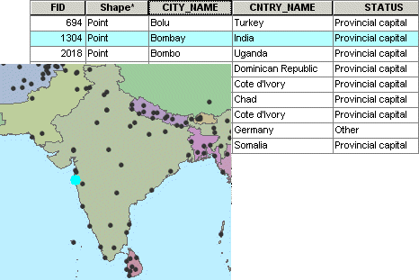
In this map of India, the city of Bombay is selected. Its record is also
selected in the attribute table. The unique identifier for Bombay is stored in the FID field.
Links
between features and attributes make it possible to ask questions about the
information stored in an attribute table and display the answer on the map.
This linkage makes GIS maps much more informative than static maps.