How is a GIS map organized?
As you saw
in the exercise, a GIS map consists of one or more data frames. A data frame
contains a collection of thematic layers. Layers, in turn, contain a collection
of features that represent real-world objects.
On a GIS map, features have a location,
shape, and a symbol. Features grouped into a layer have the same shape and
characteristics and are located within the same geographic extent. To make a GIS map, you can add as many layers as
you want.
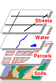
These four layers might be used by
a city government to create a GIS map. The layers all contain features located within
the city's boundaries, but each one represents a distinct "theme."
The layers are drawn on top of each other to create an informative GIS map.