Azimuthal (Planar) Map Projections
I. What is an azimuthal map projection?
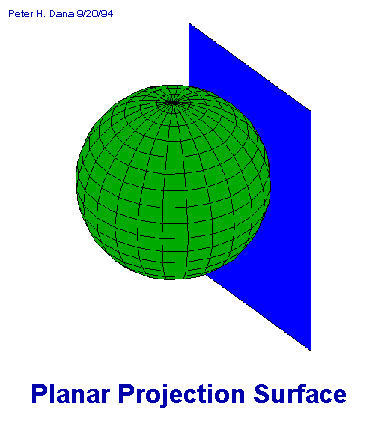
Imagine a plane being placed against (tangent
to) a globe. If a light source inside the globe projects the graticule
onto the plane the result would be a planar, or azimuthal, map projection.
If the imaginary light is inside the globe a Gnomonic projection results,
if the light is antipodal a Sterographic, and if at infinity, an Orthographic.
Sources
Text: John P. Snyder and Philip M. Voxland. An Album of Map
Projections U.S. Geological Survey Professional Paper 1453. U.S. Government
Printing Office: 1989.
Graphics: Come from two sources: 1. Paul S. Anderson, these are
graphics containing the graticule shorelines and 2. Shaded maps by Peter
H. Dana, The Geographers Craft Project. Department of Geography,
The University of Texas at Austin. http://www.utexas.edu/depts/grg/gcraft/notes
/mapproj/mapproj.html
II. Perspective Projections
- Neither conformal nor equal area.
- A perspective projection from the center of the globe onto a tangent
plane at the central point of the projection.
- Is used by navigators and aviators because great-circle paths (shortest
distances) are shown as straight lines.
- Less than one hemisphere can be viewed from a given origin.
- Scale is true only where the central parallel and meridian cross.
- All great circles are shown as straight lines.
- Conformal.
- Scale is tue only where the central parallel and meridian cross like
the Gnomonic or along a circle concentric around the center of the projection.
- All great and small circles as shown as circular arcs or straight lines.
- A perspective projection of the globe onto a tangent (or secant) plane
from a point opposite the point of the projection center.
- Used in the polar aspect for topographic maps of polar regions.
- Recommended for conformal mapping of regions that are circular in shape.
- Neither conformal or equal area.
- Scale is true at the center and along any circle centered on the projection
center but only the circumference of the circle.
- A perspective projection of the globe onto a tangent plane from an
infinite distance - it has the look of a globe.
- All great or small circles are shown as elliptical arcs or straight
lines.
- It is frequently used for views of the Earth as would be seen from
space.
III. Non-perspective Projections
- Equidistant. The distance between any two points on a straight line
passing through the center of the projection is shown at true scale.
- Can view the entire Earth.
- Used in the polar aspect for maps of polar regions, and the Northern
and Southern Hemispheres.
- Equal Area
- Can view the entire Earth.
- Scale is true only at the center but in all directions.
- Frequently used in the polar aspect in atlases for maps of polar regions
and of the Northern and Southern Hemispheres. The equatorial aspect is
used for atlas maps of the Eastern and Western Hemispheres. The oblique
aspect is used for atlas maps of continents and oceans.
- Recommended for equal-area maps of regions that are nearly circular.
- Neither conformal nor equal area.
- Scale increases gradually in all directions with distance from the
center. There is no point where scale is correct in all directions.
- The minimum-error azimuthal projection of a region enclosed by a great
or small circle at a given radius from the projection center.
IV. Modified Projections
- Conformal
- Scale is constant along a line bounding an oval region.
- It is used for an area that can be contained within an oval shape to
minimize the scale distortions in the area.
- Equidistant, interrupted, modified azimuthal.
- If viewed from the North Pole, the Northern Hemisphere is a polar Azimuthal
Equidistant projection. The Southern Hemisphere is divided into five equal
triangular lobes that are arranged in a star pattern around the Northern
Hemisphere.
- Used for the logo of the American Association of Geographers.
- Equal Area
- Elliptical border.
- Used for maps of the whole world.
Return to the Map Projection Home Page
Last modified 5/9/97by Karen Mulcahy kam@everest.hunter.cuny.edu