A Guide to Map Projections in Modern Cartography Texts, by Matthew Bazylewskyj
This page contains a review of modern cartography texts in relation to the
treatment of map projections.
Beginning almost two thousand years ago with Marinus and Ptolemy, map projections have played a very significant role in cartography. In the past, hundreds of projections have been
developed to best solve the problem of representing the spherical earth on a flat map. In recent
times, there has been an increasing number of works written on the subject of map projections.
As a student of cartography and a participant of a seminar on map projections it became clear that
the characteristics, construction, and most importantly, use of map projections were being
neglected in the face of thematic map design and advances in computer cartography.
Now more than ever, cartographers must have a thorough understanding of map projections. We
are in an era when almost everyone has the tools to create a "map".
Although the presentation of construction methods may not be necessary any longer, the characteristics and
appropriate use of different projections are still of great importance to cartography students.
In an order to test the hypothesis that map projection concepts were
being neglected 29 cartography texts were reviewed based on their coverage of the subject of map projections. A broad period of time was studied in order to note any
change in coverage over time. The oldest text was published 57 years ago and the most
recent was published this year. The following is a guide to cartography text books based on their
coverage of map projections compiled from this study. Also included are some brief statements
about the text's content and style.
After reviewing almost thirty cartography textbooks, there were a few surprises and some
expectations were met. It was a bit surprising that map projections are covered as
much as they are. Especially surprising is the fact that the amount of coverage has not changed
with time. Athough several texts contained no or little coverage of the subject, more contained a
substantial amount of information. As expected the manner in which map projections is covered
has changed over time. Today there is less emphasie on the construction of projections, while there
is more on the selection of projections. This will provide students with a better
understanding of map projections, and perhaps the more casual map maker will make better maps.
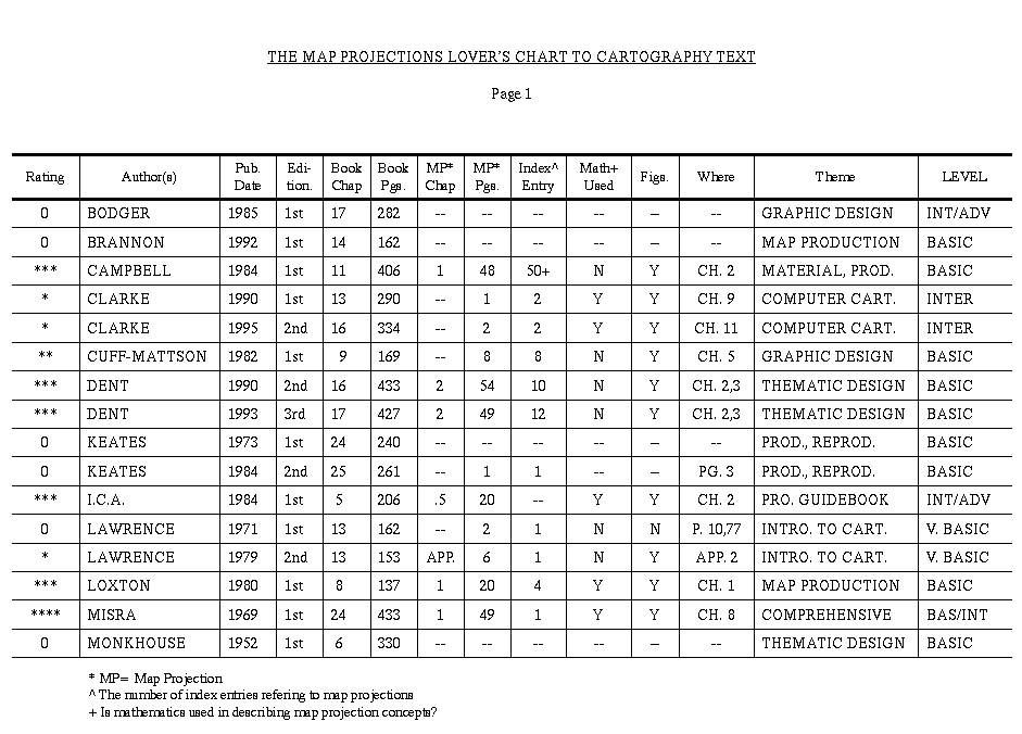
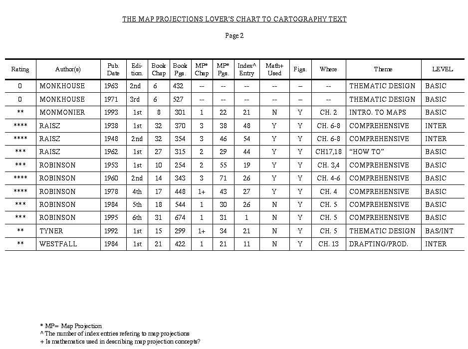
THE GUIDE
Each text book has been rated with from zero to four globes for the presentation of
map projections. A summary of all books in table form is available as page 1 and page 2.
Bodger, J. A. N. Principles of Cartography
Brannon, Gary. Practical Cartography
Campbell, John. Introductory Cartography 
Clarke, Keith C. Analytical and Computer Cartography, 1st & 2nd Eds.
Cuff, D.J. and Mattson, M.T. Thematic Maps: Their Design and Production
Dent, Borden D. Cartography: Thematic Map Design, 2nd & 3rd Eds.
Keates, J. S. Cartographic Design and Production, 1st & 2nd Eds.
ICA Basic Cartography for Students and Technicians Vol. I.
Lawrence, G. R. P. Cartographic Methods, 1st Ed.
Lawrence, G. R. P. Cartographic Methods, 2nd Ed.
Loxton, John. Practical Map Production
Misra, Rameshwar Prasad. Fundamentals of Cartography
Monkhouse, F. J. and Wilkinson, H. R. Maps and Diagrams, 1st - 3rd Eds.
Monmomier, Mark. Mapping it Out
Raisz, Erwin. General Cartography 1st and 2nd Eds.
Raisz, Erwin. Principals of Cartography
Robinson, Arthur. Elements of Cartography
Robinson, Arthur. Elements of Cartography 2nd Ed.
Robinson, Sale, and Morrison. Elements of Cartography 4th Ed.
Robinson, Sale, Morrison, and Muehrcke Elements of Cartography 5th Ed.
Robinson, Morrison, Muehrcke, Kimerling, and Guptill Elements of Cartography 6th
Tyner, Judith. Introduction to Thematic Cartography
Westfall, Claude Z. Basic Graphics and Cartography
Bodger, J. A. N. Principles of Cartography,. Perth, Australia: Technical Publications Trust, 1985.
Principles of Cartography contains no substantial information on map projections. A brief
mention of projections occurs in chapter two (Basic Elements of a Map), but only in relation to coordinate systems. There is a discussion about the Universal Transverse Mercator because of its use by
the National Mapping Council in Australia. Some definitions are
included, such as of the poles, equator, latitude and longitude, great circles, etc., but there is little available on projections themselves.
This text is fairly technical, focusing heavily on graphics. There is an especially high focus on text design. Several pages are devoted to fonts alone. The text also contains information on color
mixing, drafting techniques and production.
This text is not recommended as a teaching aid for those new to cartography. Several subjects
covered, such as plotting procedures, bearings and measurements are quite math intensive which may cause difficulty for some students.
Brannon, Gary. Practical Cartography. University of Waterloo, Ontario, Canada: Escart Press, 1992.
Practical Cartography contains absolutely nothing on the subject of map projections; not a single word. The text is focused heavily on map production, and to a slightly lesser degree, on design.
For these purposes, this text is a good source with its easy to follow reading.
Campbell, John. Introductory Cartography. Englewood Cliffs, NJ: Prentice Hall, Inc.,1984.
Introductory Cartography contains a comprehensive section on map projections. Chapter two,
entitled "Map Projections: Establishing the Graticule", is devoted entirely to map projections.
The chapter begins with an explanation of why a map projection is needed for a map. This is
followed by a discussion of scale, and globe to map relationships. Here conformality, equivalency, preservation of distance and direction are explained. Next, is a discussion of developable
surfaces which introduces the notion of the changing light source to create different projections.
Campbell then includes distortion diagrams which leads to a discussion of several specific projections. The characteristics of many cylindrical, conic, azimuthal and conventional or compromise
projections are discussed, as well as considerations for choosing a particular projections over
another. Campbell concludes with a discussion of grid systems, including state plane and UTM.
At the end of the chapter, Campbell includes a very useful list of selected readings. The chapter
gives students a comprehensive, though undetailed introduction to map projections.
Overall, the text focuses on map collection techniques, surveying, areal photography and
remote sensing. There is a technical approach with a strong coverage of cartographic materials
and production methods. Despite the technical nature, this text is fairly easy to read and a good
teaching tool.
Clarke, Keith C. Analytical and Computer Cartography. Englewood Cliffs, NJ: Prentice Hall, Inc., 1990.
Clarke, Keith C. Analytical and Computer Cartography-2nd edition. Englewood Cliffs, NJ: Prentice Hall, Inc., 1995.
Both editions of Analytical and Computer Cartography contain the same non-traditional
approach to map projections. Because these texts specialize in computer cartography, the discussion
of map projections is related to projection transformations. There is a brief discussion of the
properties of conformality and equivalency. The computer's role as a tool for projection plotting
is emphasized. The formula for the Mercator Projection is given as an example for plotting projections. Clarke refers to John Snyder's Map Projections: A Working Manual and An Album of
Map Projections for further reference. Several types of projection software is also mentioned. (For more information regarding these books see "The Map
Projection Lover's List to Map Projection Books in this Home Page.)
These texts are obviously not recommended for traditional information on map projections, but
the author acknowledges the importance of understanding projections. These texts, however, are
excellent comprehensive sources for discussion about the modern age of cartography. Due to the
technical and abstract nature of analytical and computer cartography, these texts are on a more
intermediate level of reading, and a prior knowledge of computers is helpful.
Cuff, David J. and Mattson, Mark T. Thematic Maps: Their Design and Production. New York: Methuen and Co., 1982.
Thematic Maps contains a brief look at map projections. The authors provided a very broad overview of cartography in a small amount of space, so coverage of projections is limited.
Coverage is included in part of the chapter entitled "Use of Space, Layout and Compilation".
The authors' focus on map projections is on choice, based on their characteristics (preservation of
distance, bearings, areas and shapes). A brief mention of projection classifications (azimuthal,
conic, cylindrical and miscellaneous) is included, as well as how each is derived. Probably the
most useful feature provided in this text is a table showing appropriate projections for mapping
different regions of the world, including the world itself.
The text is a very readable one, focusing primarily on thematic map design, and not a very
detailed source for projections or other technical subjects of cartography.
Dent, Borden D. Cartography: Thematic Map Design-2nd edition. Dubuque, IA: Wm. C. Brown Publishers, 1990.
Dent, Borden D. Cartography: Thematic Map Design-3rd edition. Dubuque, IA: Wm. C. Brown Publishers, 1993.
Dent's texts, as is evident from their title, are focused on thematic map design. However, both
editions include very comprehensive sections on map projections. Part of two chapters are
devoted to the topic. Chapter two is entitled "The Round Earth to Flat Map: Map Projections for Designers." The first half of this chapter is devoted to geodesy and coordinate geometry,
both plane and earth. The second half of the chapter begins with an introduction to map projections. The projection process is explained as beginning with the geoid and ending with a
reference globe. An explanation of surface transformations follows. The types of projections
(equal area, conformal, equidistant and azimuthal) are introduced along with a description of how deformation is determined and distributed.
Chapter three is entitled "Employment of Projections and Thematic Base Compilation". In this
chapter, the author acknowledges the importance of understanding projections and the use of different types for different purposes. A table is included showing suitable projections and their features for different areas. The chapter also includes descri
ptions of several types of projections for
use when mapping various areas, such as the Mollweide, Hammer, Bonne, Alber's equal area,
Lambert's conformal conic and more. The second half of the chapter is devoted to base map compilation.
The texts are well designed as an educational tool for students and they are very detailed and
comprehensive sources for thematic cartography, while providing a coverage of map projections.
Keates, J. S. Cartographic Design and Production. London: Longman Group, L.T.D., 1973.
Keates, J. S. Cartographic Design and Production-2nd edition. Harlow, Essex, England: Long man Scientific and Technical, 1989.
Both editions of this text contain practically no information on map projections. The only
mention of map projections occurs in the second edition. There the author notes that when a
sphere is projected onto a flat surface, distortion results.
Students will not find these texts to be useful for learning about
map projections, but will find them to be extremely useful for learning about map production and reproduction. The text is geared
for students, and includes helpful instruction on design.
International Cartographic Association. Basic Cartography for Students and Technicians Vol. I., 1984.
This volume published by the ICA contains five subjects in cartography written by five different authors. Chapter two, "Mathematical Cartography", was written by D. H. Maling, and contains an in depth, mathematical approach to map projections.
Maling devoted seven sections in the second half of his chapter specifically to map projections. The content of these sections is clearly described by their titles. The first is
called "Calculations involved in preparing a grid of graticule" and is heavily math oriented, containing formulas for several projections. The second section is concerned with accurately drawing a graticule manually. The third section, "Introduction to
the theory of map
projections", provides a conceptual look at projections. General deformation and scale patterns
on projections is discussed with an explanation of the ellipse of distortion and other methods of
representing distortion. The fourth section, "The fundamental properties of a map projection",
describes the conceptual construction of cylindrical, conic and azimuthal projections. The fifth
section describes the concepts of normal, transverse and oblique aspects for each of the three
types of projections mentioned above. The sixth section, "The special properties of a map projection", discusses the features of conformality, equivalency and equal distance. The seventh and
final section describes the seven classes of map projections (cylindrical, conic, azimuthal,
pseudocylindrical, pseudoconic, pseudoazimuthal and polyconic). The properties of each class is
given along with formulas.
The text provides a good general look at map projections. However, despite its title, this text is
not recommended for teaching introductory cartography due to its technical nature, though very useful as
a guide for professionals in the field.
Lawrence, G. R. P. Cartographic Methods. London: Methuen and Co. L.T.D., 1971.
Lawrence, G. R. P. Cartographic Methods-2nd edition. London: Methuen and Co. L.T.D., 1979.
Lawrence's first edition contains practically no information on map projections. Only two
pages contain any mention of the subject, and they are included with discussions of the graticule
and map errors. The author notes, "(See standard textbooks on map projections.)". The text provides a very general overview of the field without getting very detailed about how maps are made.
Both editions of this text can be used by students considering cartographic study or as a supplemental text, but shouldn't be used as the sole teaching tool for a cartography student.
The second edition contains more useful information on the subject of map projections.
Though not very detailed, the text's second appendix is devoted to map projections. The author
begins by describing the size and shape of the earth. The properties of conformality and equivalency are explained. Then a brief discussion of the conceptual construction of cylindrical, azimuthal and conic projections is included. Lawrence also mentio
ns some conventional
projections, and their qualities.
The second edition's coverage of map projections is obviously better than the first, but concepts seem
to be cut off before providing any in depth information.
Loxton, John. Practical Map Production. Chichester, England: John Wiley and Sons, 1980.
A substantial part of Loxton's text is devoted to map projections. Most of chapter one is devoted to the subject.
The chapter begins with a discussion on the nature and purpose of maps. There is then a discussion of geodesy. This is followed by an introduction to projections and their classes (perspective, azimuthal, cylindrical and conic). The differences between
tangent and secant projections
are explained. The qualities of conformality, equivalency and equal distance are described. Then
a brief discussion of Tissot's Indicatrix is included.
The end of the chapter includes the mathematical derivations of several projections. The applications for three azimuthal projections (gnomonic, stereographic, and equidistant), two conic projections (Lambert Conformal Conic and polyconic), and six cylin
drical projections (Mercator,
transverse cylindrical, Cassini, transverse Mercator and UTM) are given. As evident by the
text's title, the author focuses on projections commonly used for topographic mapping around the
world. Loxton even makes general recommendations about the type of projection to be used for different purposes.
This text is focused primarily on explaining how topographic maps are produced, and is not
very detailed about other aspects of cartography. However, it contains a useful guide to the practical applications of map projections that is easily understandable.
Misra, Rameshwar Prasad. Fundamentals of Cartography. University of Mysore, India: Parasranga, 1969.
Fundamentals of Cartography has one of the most comprehensive sections on map projections
studied. Forty nine pages are devoted to the subject and contain an abundance of information.
The chapter on map projections begins with a description of the characteristics of a globe. The
methods of deriving projections, either with a cylinder, cone or plane, is described. Several projections are described in detail. Brief histories of various projections are included, along with
simple construction methods, formulas, properties and uses. The author also provides suggested
projections for world, continental, and regional maps.
This text is not only an excellent source for information on map projections, but is an excellent source for information on cartography in general. A wide variety of topics is covered, from the
history of cartography to creating maps for children, neoliterates and the blind. This is a most unusual text.
Monkhouse, F. J. and Wilkinson, H. R. Maps and Diagrams. London: Methuen and Co., L.T.D., 1952.
Monkhouse, F. J. and Wilkinson, H. R. Maps and Diagrams-2nd edition. London: Methuen and
Co., L.T.D., 1963.
Monkhouse, F. J. and Wilkinson, H. R. Maps and Diagrams-3rd edition. London: Methuen and
Co., L.T.D., 1971.
By design, all three editions of this text contain no information on map projections. The
authors are concerned with compilation of data and presentation techniques. The first chapter is
somewhat of a glossary of materials and techniques in cartography. The following chapters
describe several types of maps (relief, climatic, economic, population and settlement). The characteristics of each is described, as well as the types of data necessary to produce them. Different
methods of presentation are also described. These texts were written with the student in mind, so
they are easy to comprehend. These editions are obviously outdated, but still provide useful
information on thematic map design.
Monmomier, Mark. Mapping it Out. Chicago: The University of Chicago Press, 1993.
The author notes that Mapping it Out is not a textbook for cartography students. This book
was designed for non-cartographers to help them begin putting a map together. The book is more
like an essay about why maps are useful in many disciplines.
In any case, this non-text is included in this guide because it contains a substantial amount of
information about map projections. Much of chapter two (Scale, Perspective and Generalization)
is devoted to map projections. The chapter begins with a discussion on scale. Then a description
of distortion and map types (conformal and equivalent) is included. The characteristics of several
projections ate noted, including Lambert's cylindrical equal area, Sinusoidal, Mollweide, Robinson and Goode's Interrupted Homolosine. The three developable surfaces (cylinder, cone and
plane) along with their distortion patterns are described. There is a brief look at perspective projections. The chapter concludes with general rules for choosing an appropriate projection.
Monmonier provides a general look at projections in a manner that is enjoyable to read. The
book is written in the first person, which makes it more personal than a traditional text. There is
also a bit of humor in Monmonier's tone. Because he did not intend for this to be a text
book, it is not as well organized as a traditional text, but he provides good examples for choosing
appropriate projections.
Raisz, Erwin. General Cartography. New York: McGraw Hill Book Co., Inc., 1938.
Raisz, Erwin. General Cartography-2nd edition. New York: McGraw Hill Book Co., Inc., 1948.
In these, the forerunners of English cartography texts, three chapters are devoted to map projections. These chapters provide detailed information on the subject.
The first of these chapters is simply titled "Projections". Here a description of equal area and
conformal projections is provided. Cylindrical projections are covered with great detail in this
chapter. The characteristics, formulas and table for the Mercator is included. A description of the characteristics and construction methods for several other cylindrical projections such as the
Sinusoidal, Goode's Interrupted Homolosine, Mollweide and Eckert IV are also included.
The second chapter of three concentrates on conical projections. The derivation of conics is
explained. The formulas and construction methods for Alber's Equal Area, Lambert's Conformal
Conic, polyconic and Bonne projections are included. The use and brief histories of these projections are also mentioned.
The third chapter focuses on azimuthal and conventional projections. The different aspects of
azimuthal projections are described, and construction methods are shown. Raisz also describes
Van Der Grinten's projections and the star interrupted projection.
These texts are somewhat math intensive, but are excellent sources for projection construction
methods. These texts are well designed as a teaching tool, and although out of date they are very comprehensive and provide student exercises.
Raisz, Erwin. Principles of Cartography. New York: McGraw Hill Book Co., Inc., 1962.
Though the organization of this text differs from the two previous texts, Raisz' coverage of
map projections is very similar to his earlier works. The same organization is followed, though
conic projections are included in the chapter with cylindrical projections. The coverage is not
quite as detailed as compared to his first texts, but still provides an in depth look at projections. A table including 14 commonly used projections with their characteristics is provided as a guide to choosing an appropriate projection. Exercises in co
nstructions are also included.
This text is even more student friendly than the previous texts. It is written very matter-of-
factly, includes a syllabus and 213 exam questions. The text is unconventionally structured, supposedly to follow the map making process. This text provides students with a "how to" approach
to cartography.
Robinson, Arthur. Elements of Cartography. New York: John Wiley and Sons, Inc., 1953.
Robinson, Arthur. Elements of Cartography-2nd edition. New York: John Wiley and Sons, Inc., 1960.
Robinson, Arthur and Sale, Randall and Morrison, Joel. Elements of Cartography-4rd edition. New York: John Wiley and Sons, Inc., 1978.
Robinson, Arthur and Sale, Randall and Morrison, Joel and Muehrcke, Phillip C. Elements of Cartography-5th edition. New York: John Wiley and Sons, Inc., 1984.
Robinson, Arthur and Morrison, Joel and Muehrcke, Phillip C. and Kimerling, Jon and Guptill, Steven C. Elements of Cartography-6th edition. New York: John Wiley and Sons, Inc., 1995.
As would be expected from a man whose interest in map projections resulted in one of the most
popular projections today, Robinson's texts all have had a very thorough coverage of the subject.
The basic approach to map projections is similar through all six editions, but there have been
some modifications made between editions.
The first edition devotes two chapters to map projections. The first is entitled "The Employment of Map Projections". The chapter begins with an explanation of a projection. A brief history of projections follows. The three classes of projections a
re described (cylindrical, azimuthal
and conic), along with a description of deformation patterns. Several projections are described in
more depth based on their characteristics of equivalency, conformality and preservation of bearings. Polyconic, equirectangualar and homolosine projections are also discussed. The chapter
ends by describing the relationship between the grid and projection.
The next chapter focuses on the construction of projections. Formulas and diagrams are provided for cylindrical, conic with one or two standard parallels, and azimuthal projections.
Three appendices are also devoted to map projections. One is a proof of Tissot's Indicatrix.
The others include tables for Lambert's azimuthal equal area and stereographic projections.
The first edition is comprehensive, but not as detailed as later editions.
The coverage of map projections is slightly different in Robinson's second edition. In addition
to the inclusion of more information, the organization of the material was changed somewhat.
The second edition includes three chapters on map projections. The first of these is entitled
"The Nature of Map Projections". This chapter includes the introduction and history of the first
edition. This chapter also includes information about types of deformation and how patterns of
deformation can be depicted.
The next two chapters are very similar to the chapters in the first edition. The same three
appendices of the first edition are included in this edition as well.
Robinson's fourth edition contains the best coverage of map projections compared to the others. Although the second edition contains more overall pages on projections, the fourth edition is more balanced between detail, organization and clarity.
The chapter on map projections begins with a brief history of projections. Scale and surface
transformation and deformation are discussed. Conformal, equal area, azimuthal and equidistant
projections are then discussed. A discussion of developable surfaces follows which includes a
description of cylindrical, azimuthal and conic projections and their deformation patterns. A
broader discussion of conformal, equivalent and azimuthal projections includes specific examples
of each. The chapter concludes with a discussion of plane coordinate systems.
Two appendices are also devoted to projections. The first provides information on the construction of map projections. Tables, formulas and explanations for several cylindrical, conic,
psuedocylindrical and azimuthal projections are provided. The second appendix shows the proof
of Tissot's Indicatrix.
This edition is an excellent source of information on map projections. The fact that the mathematics is kept separate from the concepts of projections makes this edition an excellent tool for
students. It provides students a very clear, well organized, comprehensive source in all aspects of
cartography.
Robinson's fifth edition is quite similar to the fourth. The coverage of map projections was
reduced slightly, but the same topics are discussed in the same manner. The greatest change was
the elimination of the appendix on construction methods. This was probably done due to the
growing automation of cartography.
The sixth edition retains most of the same general concepts covered in previous editions, but an
even stronger focus on distortion patterns and choice of projection is evident. This edition also
includes information on GIS, computer cartography and data processing. A box describing some
projection software is also included.
The text was reorganized with the inclusion of new coauthors, and is no longer aimed towards
the student. Though still extremely comprehensive, this edition seems to be better suited as a reference guide to the field of cartography.
Tyner, Judith. Introduction to Thematic Cartography. Englewood Cliffs, NJ: Prentice Hall, Inc., 1992.
Because Tyner's text is focused on thematic map design, its coverage of map projections is
limited primarily to choosing an appropriate projection. An entire chapter is devoted to this
purpose. The chapter begins with an explanation of map projections and the properties of a globe. The
different classes of projections (equivalent, conformal, equidistant, azimuthal and compromise)
are discussed. A description of 15 common projections including cylindrical, azimuthal, conic,
mathematical and interrupted, follows, along with the deformation patterns of each. Tyner then
discusses the criteria necessary to choose an appropriate projection. These criteria are: the subject
of the map, size and shape of an area, location, map purpose, etc. Tyner also warns strongly
against the abuse of map projections. Construction methods are not covered because the author
feels that it is not in the realm of thematic cartographers.
An appendix listing the characteristics, classifications, graticule, scale, distortion, and usage of
various projections is provided. This information, as well as most of the figures in this text were
taken from John Snyder's An Album of Map Projections.
This text provides a good coverage of projections from a thematic cartographers point of view.
It is well organized, with excellent figures, but not quite as easy to read as some other texts. A
basic to intermediate level of understanding is sufficient.
Westfall, Claude Z. Basic Graphics and Cartography. University of Maine at Orono Press, 1984.
Westfall's text provides a fairly comprehensive section on map projections. Though not
extremely detailed, most general concepts of map projections are discussed.
One chapter in this text is devoted to projections and begins with a description of why projections are needed. The desirable characteristics of projections (conformality, equivalence, direction, distance, great circles, rhumb lines and ease of cons
truction) are described. The author also
explains the cylindrical, conic, azimuthal and miscellaneous classes of projections. A table showing the characteristics of seven projections is provided, but many more are described in detail.
This text contains a highly technical approach to cartography. There is a heavy emphasis on
drafting and production. There are many complex figures which make some concepts seem overwhelming. This may present problems for some students.
Return to
The Map Projection Home Page
Last updated 9/26/97 by Karen Mulcahy - mulcahy@geog.ecu.edu