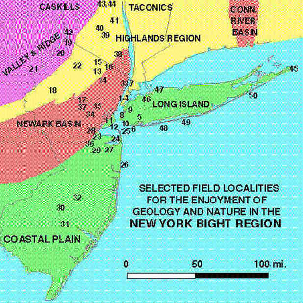
1. EMPIRE STATE BUILDING, Manhattan, NYC: what better place to see the impact of human activity? This is a fun place to go any time of the year, as long as it is a clear day! It can be windy and bitter cold in the winter, but still worth it!
2. WORLD TRADE CENTER, Wall Street, Manhattan, NY: The views of the city and the NY Harbor from the OBSERVATION level are SPECTACULAR! Because it is glassed in a visit here is great any time of year. However, check the weather before you go! Get the facts first: (212)323-2340.
3. CENTRAL PARK, Manhattan, NYC. The beautiful park displays many geologic features associated with Pleistocene glaciation as well as exposures of the beautiful "Manhattan Schist," an early Paleozoic schist and gneiss displaying amazing metamorphic features. The park is exceptionally beautiful in the spring and fall; a visit here can be made in conjunction with a visit to the:
4. AMERICAN MUSEUM OF NATURAL HISTORY: Manhattan, NYC. This museum is the absolute BEST! Where your hiking shoes; you'll need them! Dinosaurs! Amazing exhibits of fossils, animals, plants, rocks, minerals, anthropology, and much, much more! 79th Street and Central Park West; Direct access available via the B Train. Remember, some days the museum can be quite crowded for special events. Get the facts first: (212)769-5100.
5. JAMAICA BAY, Gateway National Recreation Area; Queens, NY. Visitor centers for trips to Jamaica Bay are located in two places: The Jamaica Bay National Wildlife Refuge Visitors Center is located on Cross Bay Boulevard (Queens) and the Ryan Visitors Center is located at Floyd Bennett Field on Flatbush Avenue (Brooklyn). Both "units" of the park have short hikes that provide access to views of the bay and habitats around the shore. Insects can be a major problem during the warmer months. The best time to go is during the spring and fall bird migrations. Get the facts first: (718)318-4340.
6. FORT TILDEN, Gateway National Recreation Area; Queens, NY. Fort Tilden has a short system of trails through abandoned military installations and provide access to beach, coastal dune, and "natural" barrier island environments. The best time to go is in the fall and spring (insects can be a big problem in the back beach area during the warmer months). The beach can be delightful on calm days in the winter. During the warm months the crowds from Jacob Riis Park bathing beach "spill over" onto this area. This park requires a parking permit during the summer.
7. INWOOD PARK, Bronx, NY. Inwood Park is a place most area geology students visit sometime in their education. Exceptional exposures of the Inwood Marble and other metamorphic rocks abound in the park (however, leave your rock hammers at home). This is a interesting trip on a spring or fall day, especially if you combine it with a trip to the Croton Reservoir Park, the NEW YORK BOTANICAL GARDEN or BRONX ZOOLOGICAL PARK.
8. SHORE ROAD PARK, Brooklyn, NY. A five-mile long walking/biking trail along the water front provides fantastic views of the harbor, the Verrazano Bridge, and views of the Harbor, Staten Island and the New Jersey Highlands (in the distance on clear days). This path follows the Belt Parkway between the 65th Street Pier and Caesars Bay shopping area on Bay Parkway. Bridges cross the Belt Parkway to a number of playing fields and trails through a wooded park and a pathway along Shore Road in Bay Ridge. This is a great place to spend a day walking and enjoying the scenery, combined with a meal at any number of restaurants on 3rd Avenue, or a walk through Owls Head Park (65th Street end) or a visit to Fort Hamilton Military Museum. Fantastic times to go are during Memorial Day, 4th of July, or Labor Day when lots of festivities are going on during warm weather. The rock sea wall along the bay is constructed from excavation rubble from the subway system.
9. GREENWOOD CEMETERY, Brooklyn, NY. A tour of Greenwood Cemetery is an amazing experience! Not only is a guided tour of this large historic cemetery a great place to learn history, but the landscape preserves much of the original glacial moraine topography, the grave stones are represent an amazing rock collection, and the flora is SPECTACULAR in the spring and fall. The cemetery is not open to the general public.
10. CONEY ISLAND/NY AQUARIUM, Brooklyn, NY: Coney Island is a heavily developed shorefront that forms a spit that extends westward into the outer harbor area. Coney Island Beach is accessible via the NYC subway system via the terminus of the B,D,F,M,N, and QB lines. In early walk on the beach can be combined with a visit to the NY Aquarium, as well as Coney Island attractions like Nathan's Hot Dogs, the Carousel, the Wonder Wheel, and the most guaranteed coastal hurricane-like experience: the famous Cyclone roller-coaster!
11. FRESH KILLS LANDFILL, Staten Island, NY. What? I'm not kidding! This nasty-smelling place is an amazing field trip. Any geologist or naturalist can enrich their understanding of the management and ecology of "human wastes" by planning a trip to this huge landfill. The operators allow limited "guided" field trips to the site, but must be scheduled well in advance. See the gas recovery plant, recycling facilities, and both the active and closed landfills; learn about the amazing history of the landfill, its problems and its future. Take a camera, expect to see a lot of BIRDS!
12. STATEN ISLAND SERPENTINE, Staten Island, NY: The environmental wars of the 1970s killed Robert Moses' plan to build a highway across the crest of Staten Island. As a result, road cuts carved for the uncompleted highway stand out along the Staten Island Expressway near the old campus of College of Staten Island (now BASIS - district offices of the Brooklyn & Staten Island Schools). Ownership and access to these outcrops of early Paleozoic serpentine are questionable, however, it is a tremendous outcrop full of serpentinite assemblage of minerals. The large outcrop is on the south side of the expressway.
NEW!!! The southernmost outcrop in the state of New York is a glacial till deposit next to the CONFERENCE HOUSE, a house used for a meeting between Benjamin Franklin, John Adams, and Edward Rutledge and British naval captain Christopher Billopp in a failed attempt to negotiate the end of aggression during the Revolutionary War. The house sits on a low hill overlooking the mouth of Arthur Kill and Raritan Bay.
14. NORVIN GREEN STATE PARK, Passaic County, NJ This large, forested preserve is host to a number of hiking trails that climb high, partially barren knobs of outcroppings of Precambrian granite and gneiss. The area has numerous abandoned iron mines from the Colonial Era. Spring or fall hikes are the best. Summer hikes may be too hot and buggy.
15. WAWAYANDA STATE PARK, Sussex County, NJ Wawayanda State Park is also host to a number of hiking trails that lead through forests and outcroppings of Precambrian gneiss. This area was also host to numerous iron mines from the Colonial Era. In the summer it is possible to rent kayaks and canoes to paddle around a small lake that is host to a great variety of lake and bog fauna and flora.
16. BEARFORT MOUNTAIN (Abram S. Hewitt State Forest), Sussex County, NJ: The Bearfort Ridge Trail is a relatively strenuous hike which climbs to the top of Bearfort Mountain. There are spectacular views of the valley of Greenwood Lake and the surrounding region. The rock along the ridge crest is a barren, resistant exposure of deep-red Silurian "puddingstone" (Shawangunk Conglomerate).
17. JOCKEY HOLLOW/MORRISTOWN NATIONAL HISTORIC PARK, Morris County, NJ: This historic park offers more than Revolutionary War history. It is host to a beautiful hiking trail system that wonders through forests of great trees. This park sits on the southern edge of the terminal moraine and borders the provinces of the Highlands (to the west) and the Newark Basin (north and east). This is where George Washington's army camped for one of the winters during the "Little Ice Age."
19. HIGH POINT STATE PARK, Sussex County, NJ: They highest point in New Jersey is marked by a monument on the northern end of the Kittatiny Mountains where the fold belt of the Valley and Ridge begins to peter out in its northern extent. The Appalachian Trail follows this high ridge overlooking the Delaware River valley. It would be a tragedy, however, not to include a short trip to PORT JERVIS GORGE (see below):
20. STOKES FOREST STATE PARK, Sussex County, NJ: Stokes Forest contains a variety of trails leading to the high ridge of middle Paleozoic age rocks Kittatiny Mountain providing spectacular views of the valleys of the Delaware River (west) and the Highlands region to the east. Tillman Ravine Geologic Area provides a short walk through a narrow forested gorge with small falls and rock exposures amongst a spectacular forested preserve. Stokes forest is on Route 206 in northwestern New Jersey.
21. DELAWARE WATER GAP NATIONAL RECREATIONAL AREA, Warren County, NJ: The Delaware Water Gap National Recreation Area features a variety of outdoor recreational activities. The the Delaware River has carve a great canyom through the steeply dipping Paleozoic strata that forms the resistant ridge of the the Kittatiny Mountains; Mt. Tammany on the north side of the canyon is host to a number of strenuous hiking trails that provide access to numerous vistas of the surrounding valley and region. During the warm months the Delaware River is a popular canoeing area. The visitors center has a small exhibit about the geology of the park and is a good place to gain information about the park.
22. FRANKLIN AND OGDENSBURG AREA, NJ:museums, mines, and the fascinating geology of "the Fluorescent Minerals Capital of the World." The Franklin Mineral Museum and the Sterling Mine Museum both have spectacular displays of rocks and the history of mining in the region. Franklin and Ogdensburg are off of Route 23 in northwestern New Jersey. Mineral collecting is possible in the Buckwheat Dump adjacent to the Franklin Mineral Museum for a small fee.
24. HARTSHORN WOODS, Monmouth County, NJ: Hartshorn Woods. This park contains a system of trails for hiking and mountain biking that wonder through a forested hillsides of the eastern end of the Atlantic Highlands. The sandy soil (weathering from Tertiary iron-rich sand and gravel formations) provides a refuge for mountain laurel (blooms in late May) and a plethora of wild flowers and large deciduous trees. Between the treetops are views of the scenic Navesink River valley. This park is a wonderful hike any time of year, especially in combination with a visit to Sandy Hook and/or the Monmouth Lighthouse Museum in Seabright, NJ. Even in the heat of summer, this is a wonderful cool morning hike before a trip of the beach. A beautiful view of Sandy Hook and greater Raritan Bay is possible from a scenic overlook park on the north side of Rt. 36 in Highlands, NJ about a mile west of the Navesink River bridge.
25. SANDY HOOK, GATEWAY NATIONAL RECREATION AREA, Monmouth County, NJ: From a geologic perspective Sandy Hook is one of the most dynamic places on earth. This long spit has evolved only in the past several thousand years and has changed drastically in size and shape in historic times. Sediment from longshore transport and from the Shrewsbury and Navesink rivers are continuously adding to the spit. Monstrous storms in the recent and ancient past have ripped huge parts of the spit away, creating temporary islands. Most of Sandy Hook is part of Gateway National Recreation Area. In addition to spectacular beaches the park includes a visitors center and a small museum, a number of short walks through back-beach and bayside environments. The crumbling ruins of early 20th century embattlements of Fort Hancock are surreal amongst the overgrowth. Tips for a trip to Sandy hook are provided in the Navesink Formation (late Cretaceous) which is host to a variety of marine fossils. The visitors center in the park has a small display of local fossils. This park is a good starting point for people interested in collecting fossils in the region. It is best to plan a trip here in the spring or fall (to avoid "bug season"). Fossils are most abundant after a good rain and flood waters have receded. Poricy Brook is crossed by county road 50 south of Middletown, NJ.
28. KENNEDY PARK, Middlesex County, NJ: This city park in Sayreville, NJ (near Sayreville High School) is partially surrounded by bluffs left behind by fire-clay mining operations. These bluffs, as well as many other exposures in the Sayreville area, provide exceptional exposures of the Raritan/Magothy formations of late Cretaceous age which contain lignite, rare non-marine fossils and amber.
29. ALLAIRE STATE PARK, Monmouth County, NJ: Allaire State Park straddles 1-195 near the Garden State Parkway in southern Monmouth County. Much of this park is a northern preserve of New Jersey "pine barrens" and contains a small reconstructed village from the era when "bog-iron" was mined and processed in this region. The sandy soil (weathering from the underlying late Tertiary Cohansey Sandstone) is well drained, making it essentially useless to agriculture, but home to the pine forest community adapted to this habitat.
30. APPLE PIE HILL (Wharton State Forest), Burlington County, NJ: This is an exceptional "out and back" 8 mile hike that starts at the Carranza Memorial (just south of the town of Tabernacle, NJ). This popular hike follows sand roads and a hiking trail through pinelands and cedar bogs and eventually ends on top of the highest hill in the Pine Barrens - Apple Pie Hill - where the stairs of a fire tower let you climb above the tops of the trees and allows you to see an incredible view of the central Pine Barren region (Atlantic City and Philadelphia are barely visible on the eastern and western horizons). The coarse gravel on the tops of the low hills along the trail are Beacon Hill Gravel of the upper Cohancey Formation, a remnant deposit left behind by the last high standing seas prior to the "Ice Ages."
31. PENN STATE FOREST, Burlington County, NJ: Penn State Forest is perhaps a less visited portion of the Pine Barrens region; hiking along the sand roads in this park is wonderful, especially in the winter. Bear Swamp Hill is another remnant of the Beacon Hill Gravel, a marine gravel deposit of Pliocene age (mentioned above).
32. LEBANON STATE FOREST, Burlington and Ocean Counties, NJ: Lebanon State Forest has a complex system of sand roads that wind through pine forests, cedar swamps, and "cranberry bogs" - man- made lakes where cranberries are harvested by flooding the growing fields. A visitors center near the intersection of Highway 70 and Highway 72 has maps and information about the trails. The trails are easy to mildly strenuous (because of the distances involve). Bugs can be treacherous in the warm season!
34. WATCHUNG RESERVATION, Essex County, NJ: The Watchung Mountains are the eroded remnants of late Triassic basalt flows that resist erosion better that the softer sedimentary rocks of the Newark Basin. The Watchung Reservation is a forested preserve above Scotch Plains, NJ. Ridgetop overlooks provide spectacular views of the Newark Basin region and the Manhattan Skyline in the distance.
35. SOUTH MOUNTAIN RESERVATION, Essex County, NY: South Mountain is part of the Watchung Mountains; an eroded ridge of Triassic basaltic volcanic flows. Creeks with waterfalls, and barren exposures on the hillsides allow examination of exposures the volcanic rocks. This park has a long system of trails, and is one of the closest long hikes to NYC. Hemlock Falls cuts through exposures of columnar basalts, and is a particularly scenic area within the park.
36. RARITAN RIVER/CANAL, Middlesex County, NJ: At exit 6 on I-287 the interstate crosses the Raritan River. Remaining portions the Raritan Canal follows the western bank of the River preserved in a park that bounds the river (along Highway 527). During dry seasons the water level in the river falls low enough to provide excellent exposure of Triassic redbeds (sedimentary rock) in the river bottom. The old tow path for the canal is now a hiking trail between New Brunswick and on northward of the interstate.
37. GREAT SWAMP NATIONAL WILDLIFE REFUGE, Somerset County, NJ: The plans to foil the construction of a new regional airport resulted in the preservation of this first US wildlife refuge. Great Swamp is a wetlands area that is a remnant of Lake Passaic, a lake that formed by the blockage of local rivers by glacial ice during the Pleistocene. The soggy trail system through a variety of wetlands habitats is best to see during the spring and fall migrations or when foliage is at its prime. During "bug season" forget it! Trail information can be obtained at the Great Swamp Environmental Education Center at Lord Stirling Park.
39. MOHONK HOUSE, near New Paltz, NY: A system of trails through the Shawangunk Mountains Preserve is an impressive place to spend the day or weekend, especially in the fall or the spring when the colors are best. The massive Silurian conglomerates are quite amazing; they form high cliffs popular with rock climbers. These conglomerates were carried by glacier ice throughout the regions south and east. The Mohonk House is a huge, old hotel with beautiful gardens and restaurants.
40. ICE CAVES OF THE SHAWANGUNKS, Ulster County, NY: Large blocks of Silurian rocks of the Shawangunk Mountains have slid along fractures and bedding surfaces to create a network of deep crevasses along a broken escarpment of rock. Cool temperatures allow solid ice to remain in the deepest crevasses year round. This trip requires some hiking; access is best via a trail system starting in Ellenville, NY.
41. HIGHLAND MILLS RAILROAD CUT, Highland Mills, Orange County, NY: A railroad cut in Highland Mills is an exceptional exposure of steeply-dipping, Devonian age shales, limestone, and sandstones. This has been a popular exposure for geology field trips, however EXTREME CAUTION is required because it is adjacent to rail lines with very fast moving trains.
42. PORT JERVIS GORGE: Sullivan County, NY: Port Jervis is a scenic little town nestled in the Delaware River valley at a great bend in the river that marks the boundary between NY, NJ, and PA. Along NY Route 97 north and west of town the road follows the steep-walled canyon of the Delaware River. The scenic road has many pull-offs that provide scenic views of the valley. Sedimentary rocks in the gorge area yield Paleozoic marine fossils and wood preserved in Devonian Catskill sequence of rocks. High cliffs and traffic require caution.
43. NORTH LAKE, CATSKILL MOUNTAINS, Green County, NY: A trip North Lake State Campground, near Tannersville, NY provides some of the most spectacular scenery within a long day's drive of the city. A system of trails through Hemlock woods and along ridgetop ledges of Devonian Catskill rocks. Panoramic views of the Mohawk and Hudson river valleys can be seen from North Point, one of the high points along the Catskill mountain front. A small fee is required to enter the park; trail maps are available at the park fee gate.
44. KAATERSKILL FALLS, Green County, NY: This waterfall is the highest waterfall in NY state. A stream tumbles off a high rock ledge to a deep ravine carved into Devonian age sandstones. Parking along NY Highway 23A between Tannersville and Palenville. This trail may be hazardous when wet or icy. Care should be taken when crossing the highway to the trail head.
46. PLANTING FIELDS/SAGEMORE HILL NATIONAL HISTORIC SITE, Oyster Bay, Long Island, NY: Sagemore Hill was the home of Theodore Roosevelt, the president whose love of nature helped to preserve vast areas of land as national parks. Sagemore Hill now a museum; the land sits on the hilly Ronconcoma moraine on the north shore of Long Island. A visit to Sagemore Hill is good to combine with a trip to the Planting Fields Arboretum or a visit to the north shore beaches on Long Island Sound.
47. CAUMSETT STATE PARK, Long Island, NY: Caumsett State Park is a forested preserve on a peninsula extending into Long Island Sound north of Lloyd Harbor. Caumsett has hiking trails through forested, hilly moraine to the coast along the shore. Along the water line Cretaceous-age non-marine rocks overlain by glacial moraine in sea bluff exposures. Tidal wetlands and creeks are host to a variety of sea and bird life.
48. ROBERT MOSES STATE PARK, Long Island, NY: This park is a popular bathing beach that is quite crowded during the summer, but in the fall and spring is relatively quiet. Beach, back beach dunes, and bay-side habitats and sedimentary environments are excellent places to observe local marine and bird fauna as well as coastal processes. Be advised, portions of the beach are popular for nude sun bathing.
49. FIRE ISLAND NATIONAL SEASHORE, Long Island, NY: Fire Island extends east of Robert Moses State Park for nearly 32 miles. Automobile traffic is prohibited, restricted access (via ferry) and limited development helps to maintain the wild character of this barrier island which is host to an unusual "sunken forests" behind protective back-beach dunes. Fire Island, named for the fires set to warn ships during the War of 1812, protects Great South Bay and parts of Moriches Bay from Atlantic storms and wave energy.
50. WESTHAMPTON BEACH, Long Island, NY: This site is the location of a major disaster area cause by the improper construction of groins intended to protect expensive real estate from beach erosion. Sand trapped up current from oversized groins allowed norester storms in the early 1990s to cut a great hole through a barrier island in the sediment-starved area down current form the groin field. Hundreds of houses were destroyed or damaged, and possibly as much as 100 million dollars has been spent trying to rectify the problem (at tax payers' expense).
****************************************************************
Excellent trail maps for many hiking areas in the region are
available from the NY/NJ Trail Conference. Wonderful books with
excellent trail descriptions include: Scofield, B., S.J.
Green, and H.N., 1988. Fifty Hikes in New Jersey:
Woodstock, NY: Backcountry Publ., and, McMartin, B. and P.
Kick, 1985. Fifty Hikes in the Hudson Valley: Woodstock,
NY: Backcountry Publ.
 Return to the
New York Bight Home Page
Return to the
New York Bight Home Page
Phil Stoffer and Paula Messina, 1997.